GovWire

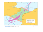
Map: Dover Strait traffic separation scheme chart

Maritime Coastguard Agency

February 1
14:47 2024

Details

A traffic separation scheme operates for vessels using the Dover Strait. This chart shows the traffic lanes in operation.

This map is not to be used for navigation.

Published 1 May 2014
Last updated 1 February 2024 +show all updates
  1. New map has been uploaded and is not to be used for the purposes of navigation

  2. First published.

Related Articles

Scroll Back To Top 📄More Articles

Comments

Scroll Back To Top Write Comment
  1. We don't have any comments for this article yet. Why not join in and start a discussion.

Write a Comment

Scroll Back To Top
Your name:
Your email:
Comments:

Post my comment

News Calendar

Recent Comments

Follow Us on Twitter

Share This


Enjoyed this? Why not share it with others if you've found it useful by using one of the tools below: